As rainfall continues to pummel parts of B.C., the province’s River Forecast Centre has issued a flood watch for the South Coast, including parts of Metro Vancouver, the North Shore, Squamish, the Fraser Valley, and the Sunshine Coast.
The Ministry of Water, Land and Resource Stewardship, which manages the River Forecast Centre, upgraded the warning from an advisory Wednesday afternoon.
CLICK HERE TO LISTEN TO LIVE WEATHER COVERAGE!
At the time, it said the South Coast can expect 50 to 150 millimetres of rain on top of the 100 to 120 millimetres at lower elevations and 150 to 170 millimetres at higher elevations from the initial pulse of the storm in the past week.
Hydrologist Jonathan Boyd says it’s difficult to pinpoint where flooding will occur.
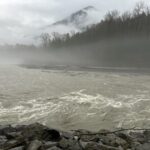
“These atmospheric rivers are notorious, where they can really shift and fluctuate,” said Boyd.
The water level on the North Shore’s Seymour River has been steadily rising, and will continue to rise over the next few days, as rain combines with snow melt.
During a flood watch, the centre advises people to stay clear of fast-flowing rivers, as their river banks may become unstable,
“It’s extremely risky to get near rivers. Oftentimes, people get more courageous under the high stream flow advisories and get close to rivers for selfies or just to have a look,” said Boyd.
“Unfortunately, dogs off-leash can get swept away. There might be people that are wanting to go for hikes in the North Shore Mountains. This isn’t necessarily the time.”


The heaviest rainfall is expected overnight Thursday through Friday.
Peter Cohen, a general manager of engineering infrastructure services, says the District of North Vancouver is keeping a close eye on the conditions.
“Rainfall intensity and the total rainfall are two factors that we really look for on the North Shore, in terms of river levels, potential flooding and the potential for any movement of debris,” said Cohen.
“For the past few days, we’ve had staff out looking at catch basins and culverts and any areas of concern that might’ve been brought to our attention.”
The district is asking residents to clear their catch basins to prevent flooding in their neighbourhoods.
The River Forecast Centre says peak flows may extend from Thursday into Saturday, reaching or exceeding two to five-year returns in many river systems.
Meanwhile, south of the border, it says Washington state is also receiving heavy rainfall.
“Based on current forecasts, overflow from the Nooksack River into the Sumas River watershed is considered a low likelihood, but still possible, scenario.”
Further north, the Central Coast Regional District (CCRD) issued a state of local emergency on Tuesday for the hamlet of Martin Valley, a few kilometres from Ocean Falls, due to the possible landslide and flood risk.
It issued an evacuation order for some homes and businesses in the community and an evacuation alert for dozens more, telling residents they need to prepare to leave quickly.
“Given the current saturated soils, unstable slopes, and ongoing weather impacts, the CCRD engaged a geotechnical specialist on Mar 17, 2026, to evaluate landslide risk,” the district said in a statement on Wednesday.
It said professional advice recommended the evacuation order due to the unknown level of life-safety risk.
Steve Emery, who represents the area at the regional district, said the flooding has damaged at least two of the approximately 40 homes in the area, as well as local infrastructure, though no one has been reported injured.
Figures released by Environment Canada show that Lennard Island, along the western shore of Vancouver Island, received 333 millimetres between Sunday and 11 a.m. on Wednesday.
Kennedy Lake Highway Station outside of Ucluelet, on Vancouver Island, received 299 millimetres during the same period, while Estevan Point had reported 295 millimetres by 11 a.m. that day.
—With files from Wolfgang Depner, The Canadian Press