Vancouver weather: Flood risk rises as heavy rain pounds B.C.’s South Coast
Parts of Metro Vancouver could get up to 120 millilitres, with the heaviest rainfall Thursday night into Friday
By Cheryl Chan
Last updated 5 hours ago
You can save this article by registering for free here. Or sign-in if you have an account.
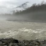
B.C.’s South Coast is in for more rain as a prolonged atmospheric river lingers over the region, increasing flooding concerns.
![]()
Subscribe now to read the latest news in your city and across Canada.
- Unlimited online access to articles from across Canada with one account.
- Get exclusive access to the Vancouver Sun ePaper, an electronic replica of the print edition that you can share, download and comment on.
- Enjoy insights and behind-the-scenes analysis from our award-winning journalists.
- Support local journalists and the next generation of journalists.
- Daily puzzles including the New York Times Crossword.
Create an account or sign in to continue with your reading experience.
- Access articles from across Canada with one account.
- Share your thoughts and join the conversation in the comments.
- Enjoy additional articles per month.
- Get email updates from your favourite authors.
Create an account or sign in to continue with your reading experience.
- Access articles from across Canada with one account
- Share your thoughts and join the conversation in the comments
- Enjoy additional articles per month
- Get email updates from your favourite authors
Sign In or Create an Account
Parts of Metro Vancouver, the Fraser Valley and the Sea to Sky region should brace for periods of heavy rain over the next two days, said Environment Canada, which issued several rainfall warnings Thursday.
![]()
tap here to see other videos from our team.
Vancouver weather: Flood risk rises as heavy rain pounds B.C.’s South Coast Back to video
![]()
tap here to see other videos from our team.
The heaviest downpours are expected Thursday night into Friday.
The North Shore and northeastern areas, including Coquitlam and Maple Ridge, are expected to receive between 80 and 130 millimetres of rain by Friday.
Metro Vancouver’s rainfall warning was upgraded from yellow, the lowest, to orange. Under Canada’s new colour-coded system, orange indicates severe weather likely to cause significant damage or disruption.
The Fraser Valley, including Abbotsford and Chilliwack, could see 100 to 120 millimetres of rain, with higher totals near the mountains.
Whistler, Pemberton and areas along the Sea to Sky Highway are forecast to receive about 75 millimetres.
Rainfall warnings for the Fraser Valley and the Sea to Sky remain yellow.
The agency also warns freezing levels near 1,500 to 2,500 metres could trigger snowmelt, which could exacerbate effects of the rain, leading to flooding, road washouts, water pooling and an increased risk of landslides.
On Wednesday, the B.C. River Forecast Centre issued a flood watch for the South Coast warning that more than 150 millimetres of rain could fall across the region by Friday.
The latest rainfall comes on top of about 100 to 120 millimetres at lower elevations and up to 170 millimetres over higher terrain over the last week.
-
Advertisement 1Story continues belowThis advertisement has not loaded yet, but your article continues below.
Earlier in the storm, a substantial amount of snow accumulated in the mountains, increasing the potential for rapid melting. Freezing levels are expected to remain elevated at around 2,000 to 2,500 metres — possibly reaching 3,000 metres in some areas — for much of the storm.
Rivers across the South Coast remained within their banks as of Wednesday, but rapid rises are expected as rainfall continues.
“River levels are already elevated and soil is saturated as the next round of the storm begins, which will likely mean a faster and more dramatic flow response,” said the centre.
The storm’s extremely long duration, heavy precipitation rates, and potentially significant rain on snow and snowmelt contributions all increase the flood hazard associated.
The flood watch is in effect for the North Shore, Metro Vancouver, Howe Sound, the Sea to Sky Corridor, the Sunshine Coast, and the Fraser Valley.
While Washington State is also expected to get heavy rain, overflow from the Nooksack River into the Sumas River watershed is unlikely, said the centre.
Environment Canada said heavy rain is expected to ease by midday Friday as a cold front moves into the Lower Mainland. Freezing levels should also drop to between 500 and 1,000 metres by Saturday.