
This Vancouver company has bagged a $3-million task order from NASA
NASA chose to work with EarthDaily because of its ‘forward-thinking’ approach to Earth imaging, says CEO Don Osborne
By Emily Renae Kapralik, National Post

A Canadian space organization has received a $3-million task order from NASA to evaluate how its commercial satellite data can be used to complement data recorded by Landsat.

Subscribe now to read the latest news in your city and across Canada.
- Unlimited online access to articles from across Canada with one account.
- Get exclusive access to the Vancouver Sun ePaper, an electronic replica of the print edition that you can share, download and comment on.
- Enjoy insights and behind-the-scenes analysis from our award-winning journalists.
- Support local journalists and the next generation of journalists.
- Daily puzzles including the New York Times Crossword.
Create an account or sign in to continue with your reading experience.
- Access articles from across Canada with one account.
- Share your thoughts and join the conversation in the comments.
- Enjoy additional articles per month.
- Get email updates from your favourite authors.
Create an account or sign in to continue with your reading experience.
- Access articles from across Canada with one account
- Share your thoughts and join the conversation in the comments
- Enjoy additional articles per month
- Get email updates from your favourite authors
Sign In or Create an Account
Landsat is the longest-running continuous U.S. Earth observation program, dating back to 1972, and the data it records is accessible to anyone across the world.
Vancouver-based EarthDaily, which launched in 2021, will provide Earth observation data to NASA and the U.S. Geological Survey (USGS), who both assist in operating Landsat.
According to an Oct. 26 press release, NASA and USGS scientists will assess the consistency and quality of EarthDaily’s satellite measurements and compare it to Landsat’s data.
Don Osborne, the chief executive officer of EarthDaily, told National Post that they were approached by NASA because “they have been contemplating a next generation series of satellites called Landsat Next,” and rather than build the infrastructure themselves, they would look for commercial imagery providers to supplement the program.
He added that NASA chose to work with the Canadian company because of its “forward-thinking” approach to Earth imaging.
“When we designed our system, one of the things that we wanted to do was to be compatible with the two major sort of gold standards for Earth imaging out there, which is Landsat in the United States and Sentinel in Europe,” said Osborne.
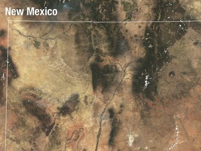
According to EarthDaily, its eight satellites can cover all of earth’s landmass in two days as they orbit the earth. Their satellites use multiple imaging systems to collect data across 22 spectral bands, covering the visible range, near-infrared, short-wave infrared and thermal infrared wavelengths.
The satellites operate in a similar manner to the Landsat satellites, which collect optical data and thermal-infrared data.
-
Advertisement 1Story continues belowThis advertisement has not loaded yet, but your article continues below.
“If you compare an image off of our satellite with an image off of Landsat, you’ll see the same specificity,” said Osborne.
The combination of EarthDaily and Landsat data will hopefully be used in order to identify patterns and broad area changes, such as coastline changes, deforestation and glacial melting.
The pilot program will seek to determine whether commercial data products are compatible with Landsat’s long term land imaging records, and if future collaborations between government-operated systems and private organizations are possible.
“Landsat has created an extraordinary scientific record of how our planet is changing,” said Osborne in the press release. “To understand change, you first need measurements you can trust and compare over time.”
In addition to land imaging, the examination will also be used to see how commercial observations can assist in machine learning and the creation of AI observation models.
“If you have poor quality data … it could create false positives,” said Osborne. “So, the real key here is to be able to produce .. standard data which is consistent from … day to day and from year to year, and we’ve gone to great lengths to make that happen.”
This will assist in NASA’s goal of expanding AI use in scientific research and in the analysis of complicated data sets.
The findings from the examination will be reviewed jointly by EarthDaily and the USGS over an undetermined time period.
Our website is the place for the latest breaking news, exclusive scoops, longreads and provocative commentary. Please bookmark nationalpost.com and sign up for our daily newsletter, Posted, here.